Skip to content

Correction sources

Different corrections sources provide varying degrees of precision. Find the one that produces the results you need for the job at hand.

oem-correctionsources-fullbackgroundhero-image

Positioning accuracies - correction signals and services

Autonomous positioning
collapse icon

When no external correction data are supplied to a GNSS receiver, it positions itself in the autonomous positioning mode with position accuracies given in the table below.

Satellite-Based Augmentation System (SBAS)
collapse icon

The Satellite-Based Augmentation System (SBAS) is based on GNSS measurements from accurately-located reference stations deployed across a continent. The differential corrections and integrity messages are broadcast over a continent using geostationary satellites as an augmentation or overlay of the original GNSS message. Systems in place delivering corrections at no cost for sub-meter positioning, examples are:

  • WAAS (USA)
  • EGNOS (Europe)
  • GAGAN (India)
  • MSAS (Japan)

If the receiver is located in the terrestrial footprint of a SBAS satellite system, better than Autonomous position accuracies can be achieved, refer to table below.

Accuracies and integrities above that obtainable from autonomous positioning require a source of differential corrections. Trimble offers various correction solutions for your applications. Choosing the best solution will depend on a number of factors including:

  • Geographical size of project
  • Accuracy levels required
  • Ability to manage GNSS receiver and communication infrastructure
GNSS RTK base
collapse icon

For smaller or local projects (<30 KM radius) requiring accuracies in the 1 centimeter level a dedicated Trimble RTK base station may be the optimum solution. This is the classical way to do RTK with virtually instant initialization.

GNSS RTK rovers
collapse icon

Full rover RTK accuracies are typically 1cm horizontal / 2cm vertical. Trimble also offers RTK rovers that operate at lower accuracy levels. For example at lower prices RTK rovers that operate at 30cm, 10cm or 5cm are available.

Alternatively, Trimble Positioning Services offers a wide range of easy-to-use GNSS correction services that remove the complexity and cost of operating base station infrastructure.

VRS Now
collapse icon

Trimble VRS Now™ is a network RTK service delivered via the internet. It provides instant access to RTK positions using a network of permanent, continuously operating reference stations. *VRS Now requires internet connection at the rover.

Visit the Trimble Positioning Services website for VRS

Trimble RTX
collapse icon

Trimble RTX® is a GNSS correction service that offers customers a variety of correction accuracy levels. Corrections are broadcasted to receivers via satellite or IP making Trimble RTX a convenient way to obtain GNSS corrections anywhere, anytime.

Visit the Trimble Positioning Services website for RTX

Initialization (coverage)
collapse icon

This is the process of calculating your position to a desired accuracy level. When a receiver’s position reaches full accuracy then it is considered to be fully initialized.

Correction source descriptions and comparison table
collapse icon

comparisontable

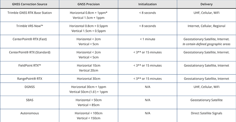
All precision values 1 sigma performance based on repeatable in field measurements. Achievable accuracy and initialization time may vary based on type and capability of receiver and antenna, user’s geographic location and atmospheric activity, scintillation levels, GNSS constellation health and availability, and level of multipath including obstructions such as large trees and buildings.

  • ppm means 1 part per million of the distance to the local base station, i.e. 1mm per 1km distance from the base station

** <3 mins for Trimble ProPoint receivers

Contact us

We'll take you precisely where you need to go.